Displaying 101 - 110 of 305
![](/sites/default/files/styles/lis/public/taal-volcano.jpg.webp?itok=YYaj5qrI)
![](/sites/default/files/styles/lis/public/Australia%20Flood%20Extent%20Feb-March%202022.jpg.webp?itok=LEA83blx)
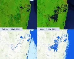
The fresh water resource in lower Mekong is confronted with challenges due to uncoordinated human activity in the upstream regions, such as extraction, diversion and...
![Predicted cheatgrass green-up imagery from Landsat 8 OLI data. This composite image of the western portion of the Mullen Fire Study Area is from June 2022. Shades of green and yellow indicate an earlier green-up time, while orange, brown, and white areas show later predicted green-up times. This data was used to create NDVI difference maps which will help managers predict when and where to apply treatments to limit the spread of cheatgrass.](/sites/default/files/styles/lis/public/2023-10/2023Sum_CO_SouthernWyomingEcoII_WebsiteImage.jpg.webp?itok=Ht2hUpEj)
Southern Wyoming Ecological Conservation II (Summer 2023) Team: Bryan Graybill (Project Lead), Lillian Gordon, Estelle Lindrooth, Sarah Sathe Summary: Cheatgrass (Bromus tectorum) is an invasive...