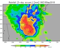
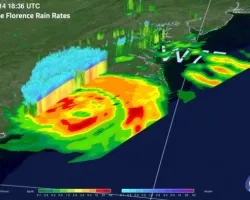
UPDATE 9/17/18: Remnants of Hurricane Florence are now a post-tropical cyclone moving over the Mid-Atlantic states. To date, the storm has caused approximately 25 deaths. Tens of thousands of homes in the Southeast, including the Carolinas, have been damaged as floodwaters continue to rise, and numerous communities, including the City of Wilmington, NC are cut off by the floodwaters. Search and rescue operations are continuing, and thousands of people remain in shelters. NASA Scientists have begun to map the floodwaters by aircraft using Synthetic Aperture Radar (SAR) which has the ability to see through clouds to more concisely map the floodwaters and aid first responders as well as in the recovery effort.
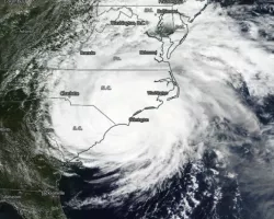
UPDATE 9/14/18: Hurricane Florence made landfall at 7:15 AM EDT near Wrightsville Beach, North Carolina as a Category 1 hurricane with estimated maximum winds of 90 mph. As of 5 PM EDT, Florence is now a tropical storm with estimated maximum winds of 70 mph and is located near the North Carolina-South Carolina border. It is forecasted to move across South Carolina and weaken into a tropical depression by Sunday. NASA Earth Science is bringing all relevant observations and science expertise to bear on Hurricane Florence before, during, and after landfall to provide situational awareness to stakeholders and the public. The intent is to provide a more comprehensive awareness throughout the entire disaster life cycle.
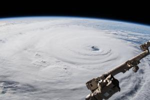
UPDATE 9/12/18: With Category 4 Hurricane Florence less than 48 hours from making landfall on the Southeast Coast, the NASA Disasters program has been hard at work identifying geographically referenced science information products for response partners like FEMA, the National Guard, USGS and more. The Disasters team has been providing a variety of satellite and airborne remote sensing capabilities to aid storm preparedness, response, and recovery efforts. As flooding is one of the primary threats during this event, much of what the Disasters program will be providing will be related to information on flooding. Hurricane Florence could be the strongest storm to target the Carolinas in decades, FEMA officials have said.
Related Impact