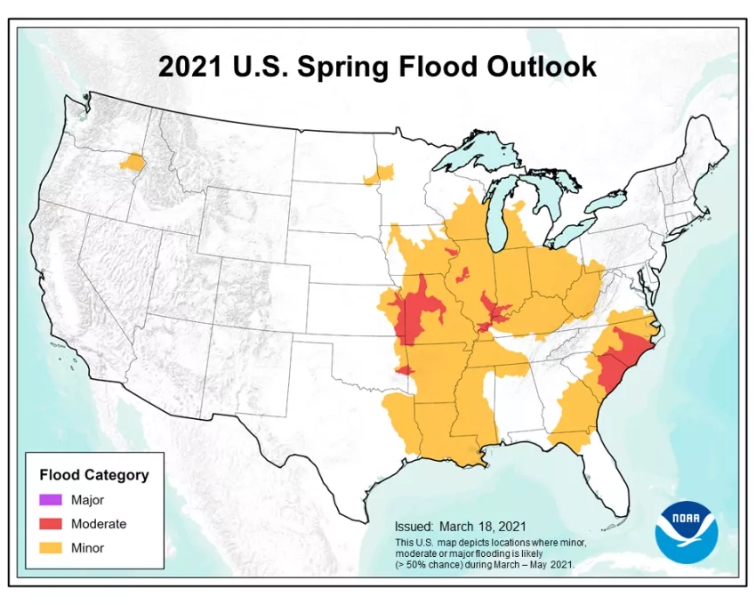
The National Oceanic and Atmospheric Administration (NOAA) expects that spring flooding across the U.S. will not be as severe or as prolonged as the previous two years, according to their Spring Outlook for 2021. NOAA hydrologists are forecasting limited moderate flooding this spring, while noting that heavy rainfall at any time can lead to flooding, even in areas where the overall risk is considered low. NOAA projects that the drought conditions currently affecting nearly half the country will likely continue and expand throughout the year.
The Spring Outlook is released yearly to inform the American public what weather patterns they can expect for the upcoming season. This outlook helps emergency managers and community decision-makers along the nation’s major waterways prepare for the threat of floods and minimize their effect on lives and livelihoods. Flood risk can change rapidly, and NOAA's forecasts and outlooks will serve as a valuable resource for emergency managers and community decision-makers as they navigate all potential extreme seasonal weather and water events.
In the United States, floods account for more deaths than any other disaster, resulting in more loss of life and property than other types of severe weather events. To mitigate this, NOAA’s National Weather Service (NWS) River Forecast Centers provide routine official river forecasts, and Weather Forecast Offices issue watches and warnings to protect life and property when the threat of flooding does occur. NOAA’s National Water Center in Tuscaloosa, AL, coordinates, facilitates and integrates development activities across NWS hydrologic services and works to strengthen the nation’s water forecast capabilities for floods and droughts. NOAA’s National Ocean Service (NOS) also aids coastal flood response efforts, working with disaster response agencies such as FEMA to provide a broad range of scientific, technical, and policy expertise to support response and inform recovery when disaster strikes.
NASA combined data from multiple satellites to estimate the rainfall from Hurricane Sally in September 2020. Credits: NASA
With its fleet of Earth-observing satellites and aircraft, NASA also provides a broad range of tools and expertise that help study, monitor and understand flood hazards and support response efforts in the U.S. Data gathered by these instruments contribute to researchers’ understanding of the physical processes within storms, which aids in building models to predict flooding and forecast future weather patterns. The Global Modeling and Assimilation Office (GMAO) aims to maximize the impact of satellite observations in climate, weather, and atmospheric prediction using comprehensive global models and data assimilation from multiple instruments. The Joint Center for Satellite Data Assimilation (JCSDA), a partnership among NASA, NOAA, and the U.S. Department of Defense, works to accelerate and improve the use of research and operational satellite data in weather, ocean, climate, and environmental analysis and prediction models. The Short-term Prediction Research and Transition (SPoRT) Center transitions the data from NASA research satellites such as GPM, Aqua, Terra and SMAP, to the NWS Weather Forecast Offices to improve short-term forecasts on a regional scale.
NASA satellite data are also used to observe the impacts of individual weather events and provide valuable data for decision-making to responders on the ground. For example, near real-time mapping of rain rates by the GPM satellite constellation can provide responders with valuable awareness of which regions may expect to see flash flooding and river inundation. Data derived from SMAP are used to analyze soil moisture conditions in advance of storms to help anticipate the impact of heavy rainfall and identify regions that are more likely to experience runoff and flooding. After a strong rainfall event, flooded regions can be mapped using optical instruments including MODIS aboard NASA’s Terra and Aqua satellites, VIIRS aboard the NASA / NOAA Suomi-NPP satellite, or OLI from the USGS / NASA Landsat-8 satellite. Should post-storm cloudiness obscure a view of the land surface, Synthetic Aperture Radar (SAR) satellite data can be used to map water extent and inland flooding.
Click here for more NASA Earth data resources related to floods.
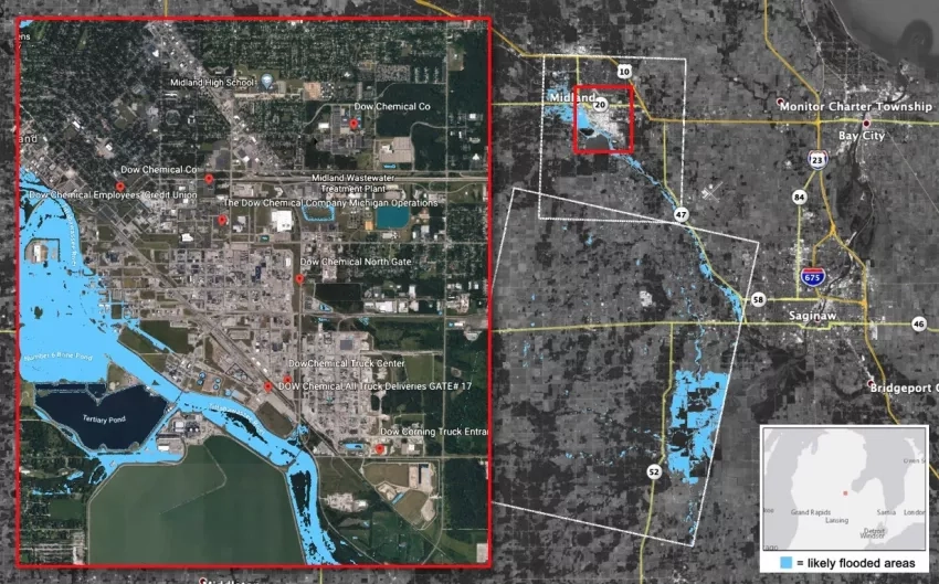
The Disasters program area of NASA’s Earth Science Applied Sciences Program coordinates directly with local governments and response agencies such as FEMA to help assess flood impacts and inform actionable decisions through all phases of the emergency management cycle. In 2020, NASA aided response efforts for several significant flood events in the U.S, such as the May 2020 flooding in Midland County, Michigan, that resulted in the failure of the Edenville and Sanford Dams. In Nov. 2020, NASA Marshall Space Flight Center researchers coordinated with representatives from the North Carolina Department of Public Safety. The researchers used optical and SAR satellite data to generate several false-color maps of flooding in the region to demonstrate remote sensing capabilities for flood detection. The Program also worked tirelessly to support response efforts for the record-breaking 2020 hurricane season, which saw 12 named storms make landfall in the continental U.S., bringing storm surges and flooding from heavy rainfall to coastal communities.
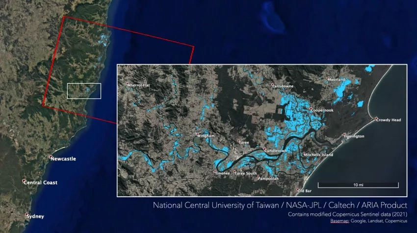
The Disasters program also funds innovative applied research to demonstrate the applications of Earth-observing data to study disasters and to mature these technologies to operational use, both in the U.S. and around the world. For example, the ROSES A.37 project, Advancing Access to Global Flood Modeling and Alerting using the PDC DisasterAWARE Platform and Remote Sensing Technologies uses Earth-observing data to determine the extents of floods and assess damage. Products from this project feed into a unified global risk assessment and alerting system to support end-users and inform disaster response decisions. When hurricanes Eta and Iota struck Central America in Nov. 2020, the project Integrating SAR Data for Improved Resilience and Response to Weather-Related Disasters worked with the USDA Foreign Agricultural Service to identify flooded regions and impacts to agriculture. And in March 2021, the Global Rapid Damage Mapping System with Spaceborne SAR Data project, working with the National Central University of Taiwan, produced SAR-based maps to identify flooded areas in New South Wales, Australia.
NASA supports the U.S. flood season by developing new methods and techniques for analyzing and distributing Earth data, and by collaborating with agencies including NOAA and FEMA to help strengthen communities to mitigate future flood hazards. The NASA Disasters program stands ready to aid communities by providing cutting-edge research and NASA data that enhance emergency managers’ expertise as they tackle the challenges that floods will bring in 2021 and beyond.
Learn more about how NASA supports risk reduction, response, and recovery for floods.