Displaying 21 - 30 of 64
Topic
Identifying key biodiversity areas is crucial to understanding how endangered species populations react to changes in climate and urbanization. The project focuses on the fluctuations...
![Satellite image](/sites/default/files/styles/lis/public/2022-01/sfmis_podest_credit_Sentinel-2_and_PALSAR_v2.jpeg.webp?itok=P6DtuUR8)
Topic
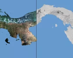
The country of Panama is surrounded in part by two oceans and has mountain ranges along the west and east, resulting in a wide range...
![Trout in pool of water](/sites/default/files/styles/lis/public/2022-01/Trout%20Pool%207x5x300%20CYMK_from.Fred_.Feb_.4.2020.jpg.webp?itok=sefpsjx6)
Topic
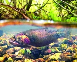
Aquatic invasive species (AIS) presence in freshwater ecosystems has increased over the past several years as a result of climate change and anthropogenic landscape change...
![Shark with open mouth](/sites/default/files/styles/lis/public/2022-01/01_colortiger%20%28Photo%20credit%20Dr.%20Tom%20Burns%29.jpg.webp?itok=6TkUuKye)
Topic
As Earth’s oceans undergo dramatic changes, the spatial distributions of highly migratory species and fishing fleets are shifting in response to climate-driven changes, and there...
Topic
Increasing temperatures, as well as more severe and frequent droughts and fires, has led to recruitment failure in semi-arid forests in the western US. The...
![Two people inspecting water hyacinths](/sites/default/files/styles/lis/public/2022-01/Wood_water%20hyacinth.jpeg.webp?itok=9vFE7oum)
Topic
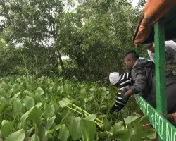
Local companies and scientists in Benin are increasing their use of earth science information to manage forests and water resources. The invasive water hyacinth plant...
Topic
Gold mining is a central component of Ghana’s economy. An increased amount of illegal artisanal mining in recent years has led to accelerated deforestation, destruction...
![Normalized Difference Moisture Index (NDMI) processed 2021 Landsat 8 OLI imagery over land and Sentinel-2 MSI over ocean, ranging from yellow (low) to blue (high), for Hilo, Hawaii. Overlayed with four-day rainfall accumulation cells in blue acquired during Hurricane Lane (Aug 22-25, 2018) from CHIRPS Daily. NDMI monitors water content of leaves and is useful for classifying land cover. Impervious surfaces and areas that have received excessive historical rainfall are susceptible to future flood events.](/sites/default/files/styles/lis/public/2022-03/2021Fall_AZ_HawaiiIslandDisasters_WebsiteImage_1440.png.webp?itok=UF3NMIoI)
Hawai‘i Island Disasters (Fall 2021) Team: Garren Kalter (Project Lead), Rose Eichelmann, Sanketa Kadam, Erin Azuma, and Anna Mikkelsen Summary: As the County of Hawai‘i...
![Landsat 8 OLI derived MNDWI imagery mosaicked from October 17, 2020, to December 2, 2020. Located near the Río Patuca (Patuca River) in Ahuas, Honduras, permanent water and flood is represented as bright red and orange while blue depicts other land cover types and clouds. Examining floods from disasters like Hurricanes Eta and Iota helps decision makers improve mitigation and response efforts.](/sites/default/files/styles/lis/public/2022-03/2021Fall_MSFC_CentralAmericaDisasters_WebsiteImage.png.webp?itok=pweSILBO)
Central America Disasters (Fall 2021) Team: Caroline Williams (Project Lead), Lauren Carey, Maria De Los Santos, Deanna Fanelli, and Payton Ireland Summary: In November 2020...
![NDTI-processed imagery using 1999-2021 Landsat 7 ETM+ and Landsat 8 OLI data, processed with SHARQ and ORCAA. Displayed is an East-oriented view of St. Joseph Peninsula off the Florida panhandle. Brighter shades of pink indicate greater change in turbidity levels post-Hurricane Michael, while shades of purple represent lower turbidity change. This increase in sediment post-hurricane indicates disturbed aquatic vegetation due to extreme storm events.](/sites/default/files/styles/lis/public/2022-03/2021Fall_MSFC_StJosephPeninsulaDisasters_WebsiteImage.png.webp?itok=zl4XgGUp)
St. Joseph Peninsula Disasters (Fall 2021) Team: Erica Kriner (Project Lead), Paige Aldenberg, James Byrne, Brianne Kendall, and Nicholas Roberge Summary: T.H. Stone Memorial St...