Displaying 161 - 170 of 305
![The image was collected by Landsat 9 on January 26 of 2023 showing Skidaway Island and waterways on the Georgia coast. The data shows areas of healthy vegetation and urban areas using a Normalized Difference Vegetation Index (NDVI). The darker orange represents grass and urban areas. Yellow and purple represents forested and densely vegetated areas. The black represents open water.](/sites/default/files/styles/lis/public/2023-05/2023Spring_GA_GeorgiaDisastersII_WebsiteImage.jpg.webp?itok=zhMhpiSz)
Georgia Disasters II (2023 Spring) Team: Shakirah Rogers (Project Lead), Nathan Tesfayi, Matthew Murray, Clarence Jackson Summary: Heirs property owners are especially vulnerable to natural...
![An NDWI waterbody mask derived from Landsat-8 OLI cloud-masked imagery from March-May 2019-2021 is shown in blue at 10-meter resolution over Mexico, Belize, and Guatemala. The ALOS-PALSAR-2 fine-beam L-band false color composite includes Refined Lee speckle filtered HV, HH, HH/HV bands. Darker and brighter green hues represent to low and high backscatter, respectively. Differentiating between open water, like the Hondo River, from vegetated inundation is important when distinguishing inundation by land cove](/sites/default/files/styles/lis/public/2022-03/2021Fall_JPL_MayaForestWaterResourcesII_WebsiteImage.png.webp?itok=WSwTB7q7)
Maya Forest Water Resources II (Fall 2021) Team: Stephanie Jiménez (Project Lead), Karen Alvarez, Rene Castillo, Daniel Nohren, and Stephanie Lawlor Summary: To monitor seasonal...
![2022 Spring MSFC Okefenokee Water Resources Website Image](/sites/default/files/styles/lis/public/2022-06/2022Spring_MSFC_OkefenokeeWaterResources_WebsiteImage_v2.png.webp?itok=aAUGYAb3)
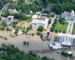
Okefenokee Water Resources (Spring 2022) Team: Brianne Kendall (Project Lead), Kyle Steen, Hailey Schmidt, Laramie Plott Summary: The Okefenokee Swamp is a vital ecosystem known...
Topic
Description: This project provides a range of surface water products related to lakes, reservoirs, and wetlands in a near real time framework. It also offers...
Topic
Description: This project provides a range of surface water products related to lakes, reservoirs, and wetlands in a near real time framework. It also offers...
![](/sites/default/files/styles/lis/public/images/develop-legacy/2020/summer/images/2020Sum_CO_RockyMtnDisasters_WebsiteImage.jpg.webp?itok=KfhOwFZe)
Topic
Forest composition and structure in the Colorado Front Range has been altered by changing wildfire regimes. In particular, increased moderate- and high-severity fire significantly reduces...
Topic
This proposal aims to expand a lake and reservoir monitoring program. This program is on-line, operational, with an existing decision support system (DSS) in place...
![](/sites/default/files/styles/lis/public/Vermont-flooding-DOD.jpeg.webp?itok=HIf3Cc1H)