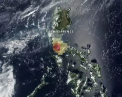
Displaying 101 - 110 of 305
![](/sites/default/files/styles/lis/public/taal-volcano.jpg.webp?itok=YYaj5qrI)
![](/sites/default/files/styles/lis/public/Australia%20Flood%20Extent%20Feb-March%202022.jpg.webp?itok=LEA83blx)
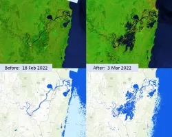
The fresh water resource in lower Mekong is confronted with challenges due to uncoordinated human activity in the upstream regions, such as extraction, diversion and...
![Forest cover and land surface temperature (LST) around Maine's Penobscot River during Summer 2021. The shades of green distinguish between evergreen (dark) and deciduous (light) forest which were classified using Landsat 8 OLI imagery. The purple gradient corresponds to LST derived from Terra MODIS where the warmest areas, including Bangor, are white. Changing land use and warming temperatures along Maine’s rivers are associated with reducing juvenile Atlantic salmon (Salmo salar) survivorship.](/sites/default/files/styles/lis/public/2022-11/2022Sum_GSFC_MaineEcoIII_WebsiteImage.jpg.webp?itok=EiYDdUqO)
Maine Ecological Forecasting III (Summer 2022) Team: Jonathan Falciani (Project Lead), Colin Hogan, Linda Mitchell, Makario Sarsozo Summary: Shifting patterns in land use and land...