Displaying 61 - 70 of 94
![NDVI over Mato Grosso, Brazil processed from March 2021 Landsat-8 OLI data. Calculated NDVI values correspond with colors shown to indicate plant health. High NDVI values (green to blue) indicate dense vegetation found in tropical and temperate forests or crops at their peak growth. Low values (yellow to red) depict barren land, water, and moisture-stressed vegetation. These data can support timely and efficient agricultural responses to ensure productive yields and food security.](/sites/default/files/styles/lis/public/2022-12/2022Sum_NC_MatoGrosso_WebsiteImage_FD.png.webp?itok=JJA3kKJi)
Mato Grosso Agriculture (Summer 2022) Team: Max Rock (Project Lead), Elijah Dalton, Aidan Harvey, Kate Reynolds Summary: Ranked as the fourth largest food producer in...
![](/sites/default/files/styles/lis/public/images/develop-legacy/2019/summer/images/2019Sum_MSFC_CentralAmericaTI_WebsiteImage.jpg.webp?itok=DWQOzdqL)
Topic
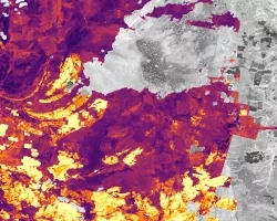
Central America is one of the world’s most vulnerable regions to natural disasters, including landslides and precipitation-driven flooding. In an effort to support disaster management...
![NDWI-processed composite image from Landsat 8 OLI data of the Lower Illinois River Valley and surrounding landscapes from summer 2021. Shades of pale yellow indicate dry vegetation and dark teal represents open water, while brighter turquois values depict wet vegetation. Areas of high NDWI values are demonstrative of high presence of wet vegetation and are of interest to the Great Rivers Land Trust in identifying areas of interest for wetland conservation.](/sites/default/files/styles/lis/public/2022-12/2022Sum_JPL_LowerIllinoisEco_WebsiteImage.png.webp?itok=eCvz2h8C)
Lower Illinois River Valley Ecological Forecasting (Summer 2022) Team: Vanessa Machuca (Project Lead), Dana Myers, Hannah Rigdon, Christiana Saldana Summary: The Lower Illinois River Valley...
![Normalized Difference Water Index (NDWI) to visualize drainage networks around the Unalakleet River in Alaska, calculated from an August 2021 Landsat 8 OLI image. Yellow represents standing or flowing water and potential flood zones, while the dark blue represents drier, upland regions. Unalakleet's climate resilience planning prioritizes relocation to upland regions while avoiding areas that have experienced significant permafrost degradation.](/sites/default/files/styles/lis/public/2023-10/2023Sum_GA_UnalakleetClimate_WebsiteImage.jpg.webp?itok=9m9RUwoB)
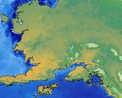
Unalakleet Climate (Summer 2023) Team: Ian Lee (Project Lead), Clara Maxwell, Daniel J. Marsden, M. Jaweed Nazary Summary: The coastal community of Unalakleet is currently...
![2022 Spring MSFC Okefenokee Water Resources Website Image](/sites/default/files/styles/lis/public/2022-06/2022Spring_MSFC_OkefenokeeWaterResources_WebsiteImage_v2.png.webp?itok=aAUGYAb3)
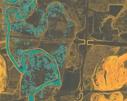
Okefenokee Water Resources (Spring 2022) Team: Brianne Kendall (Project Lead), Kyle Steen, Hailey Schmidt, Laramie Plott Summary: The Okefenokee Swamp is a vital ecosystem known...
![](/sites/default/files/styles/lis/public/images/develop-legacy/2020/summer/images/2020Sum_CO_RockyMtnDisasters_WebsiteImage.jpg.webp?itok=KfhOwFZe)
Topic
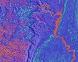
Forest composition and structure in the Colorado Front Range has been altered by changing wildfire regimes. In particular, increased moderate- and high-severity fire significantly reduces...
![](/sites/default/files/styles/lis/public/images/develop-legacy/2020/spring/images/2020Spring_LaRC_ToaBajaDisasters_WebsiteImage.jpg.webp?itok=-G6z6Qcj)
Topic
Toa Baja, located just west of San Juan in Puerto Rico, is known as “the underwater city” due to its propensity to flood. The city...
![](/sites/default/files/styles/lis/public/images/develop-legacy/2018/spring/images/LRC-2018-E3-G_2018Spring_CO_UTWaterResources_WebsiteImage_00000.png.webp?itok=qcgcESTJ)
Topic
Since 1971, federal agencies have been tasked with managing burros in federally-designated herd management areas (HMAs). Because these areas are often large and remote, obtaining...
![](/sites/default/files/styles/lis/public/images/develop-legacy/2018/spring/images/LRC-2018-E3-G_2018Spring_CO_MinnesotaTexasAgriculture_WebsiteImage_00000.jpg.webp?itok=nHqXIij6)
Topic
Northern wild rice (Zizania palustris L.) and Texas wild rice (Zizania texana) provide valuable ecosystem services, food sources, economic development, and cultural resources to local...
![](/sites/default/files/styles/lis/public/images/develop-legacy/2017/summer/images/LRC-2017-E3-G-2017Sum_FC_AlaskaClimate_WebsiteImage_00085.jpg.webp?itok=DrKFls5U)
Topic
The rapid expansion of purple loosestrife (Lythrum salicaria) and reed canarygrass (Phalaris arundinacea L.) into aquatic and wetland systems has reduced native plant abundance, decreased...