
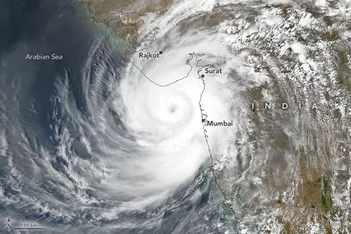
On May 17, 2021, the first cyclonic storm of the 2021 North Indian Ocean cyclone season, Cyclone Tauktae, landed on the southern coast of the Indian state of Gujarat. According to the U.S. Joint Typhoon Warning Center, Tauktae was the equivalent of a category 3 hurricane at landfall, with maximum sustained winds estimated at 125 mph (185 kph). That makes it the strongest tropical cyclone in at least two decades to impact the west coast of India. It was also the strongest tropical storm to skirt the city of Mumbai since satellite data became available in the 1970s, with the eye of the storm moving within 150 km of the commercial capital.
Before making landfall, Tauktae brought heavy rainfall and flash floods to other areas of India’s west coast. Authorities have evacuated approximately 200,000 in the region with deaths and damage reported in the states of Kerala, Karnataka, Goa, and Maharashtra. Gujarat and Mumbai both also suspended COVID-19 vaccination drives due to the approach and impacts of Cyclone Tauktae.
The NASA Earth Applied Sciences Disasters Program has activated for Cyclone Tauktae and is monitoring the situation to identify potential stakeholders and determine what NASA resources and capabilities may be available to support response and recovery for the event.
NASA combined data from multiple satellites in the GPM Constellation to estimate precipitation rates and totals from Tropical Cyclone Tauktae in May 2021. The animation shows precipitation rates (blue/yellow shading) and accumulations (green shading) at half-hourly intervals from May 12-19, 2021, derived from NASA's IMERG algorithm. Underneath the precipitation data, cloud cover is shown in shades of white/gray based on geosynchronous satellite infrared observations. On top of the precipitation data, the cyclone's approximate track is displayed based on estimates from the Joint Typhoon Warning Center (JTWC). Credits: Jason West/NASA GSFC
The NASA Disasters program has several research projects focused on studying and mitigating impacts from tropical cyclones and extreme weather events in its ROSES A.37 portfolio.
The A.37 project, “Open Critical Infrastructure Exposure for Disaster Forecasting, Mitigation and Response,” focuses on the India and Southeast Asia regions. With that project, the Program is looking into comparison of Critical Infrastructure Interdependency Risk Index (CIIRI) and Critical Infrastructure Interdependency Index (CIII) with the actual events. Hazard data was donated to the Principal Investigator, Charles K. Huyck, by commercial partners at the Kinetic Analysis Corporation.
Other A.37 research projects that have applications for tropical cyclones and extreme weather events include: “Advancing Access to Global Flood Modeling and Alerting,” “Enabling Landslide Disaster Risk Reduction and Response Throughout the Disaster Life Cycle with a Multi-Scale Toolbox,” “Integrating Synthetic Aperture Radar Data for Improved Resilience and Response to Weather-Related Disasters,” and “Global Rapid Damage Mapping System with Spaceborne Synthetic Aperture Radar (SAR) Data.”
The ROSES A.50 project “GEO GFRM Integrating Global Remote Sensing and Modeling Systems for Local Flood Prediction and Impact Assessment Project” also has applications for tropical cyclones. Learn more: https://disasters.nasa.gov/portfolio.
Other products: