Displaying 141 - 150 of 305
![NDWI-processed imagery from Landsat 8 Operational Land Imager data. This mosaicked image was taken from January to December 2021 of Jekyll Island, Georgia. NDWI contrasts the water features in a satellite image to its surroundings by measuring the moisture content. Low moisture content is shown in white, and high moisture content is shown in blue.](/sites/default/files/styles/lis/public/2023-02/2022Fall_GA_Disasters_WebsiteImage.png.webp?itok=_4Frkxe1)
Georgia Disasters (Fall 2022) Team: Isabella Chittumuri (Project Lead), Nancee Uniyal, Nathan Tesfayi, Shakirah Rogers Summary: In September 2017, Hurricane Irma made landfall in southern...
![2022 Spring PUP Mexico Disasters Website Image](/sites/default/files/styles/lis/public/2022-06/2022Spring_PUP_MexicoDisasters_WebsiteImage_v2.png.webp?itok=3ZfxI279)
Mexico Disasters (Spring 2022) Team: Philip Casey (Project Lead), John Willis, Sean Nelsen, Zachary Silberman Summary: In this project, NASA DEVELOP partnered with Mexico’s National...
![](/sites/default/files/styles/lis/public/images/develop-legacy/2021/spring/images/2021Spring_JPL_CCWR_WebsiteImage_V3.jpg.webp?itok=YZI9AtzT)
Topic
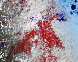
Estuaries are vital ecosystems that serve important ecological functions. The Marine Life Protection Act aims to protect these ecosystems by establishing a network of marine...
![This map produced from JAXA ALOS-2 satellite data shows surface displacement caused by the 7.4 magnitude earthquake in Mexico. Credit: NASA, JAXA Sang-Wan Kim, Batu Osmanoglu, and Min-Jeong Jo](/sites/default/files/styles/lis/public/2020-06/ALOS-2-deformation-map-mexico-earthquake-2020.jpg.webp?itok=3Pmvha3y)
![](/sites/default/files/styles/lis/public/images/develop-legacy/2019/summer/images/2019Sum_AL_MobileUrban_WebsiteImage.jpg.webp?itok=581tgURE)
Topic
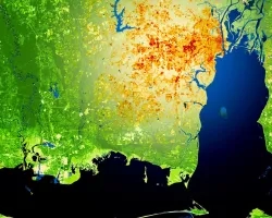
This project utilized satellite Earth observations to assess locations in Mobile County, Alabama, that are vulnerable to the urban heat island effect (UHI) and flood...
Topic
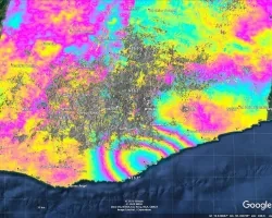
When an earthquake occurs, seismic data provides an initial estimate of magnitude and location. However, for large earthquakes, we can improve our situational awareness once...
![NDVI over Mato Grosso, Brazil processed from March 2021 Landsat-8 OLI data. Calculated NDVI values correspond with colors shown to indicate plant health. High NDVI values (green to blue) indicate dense vegetation found in tropical and temperate forests or crops at their peak growth. Low values (yellow to red) depict barren land, water, and moisture-stressed vegetation. These data can support timely and efficient agricultural responses to ensure productive yields and food security.](/sites/default/files/styles/lis/public/2022-12/2022Sum_NC_MatoGrosso_WebsiteImage_FD.png.webp?itok=JJA3kKJi)
Mato Grosso Agriculture (Summer 2022) Team: Max Rock (Project Lead), Elijah Dalton, Aidan Harvey, Kate Reynolds Summary: Ranked as the fourth largest food producer in...
![](/sites/default/files/styles/lis/public/images/develop-legacy/2019/summer/images/2019Sum_MSFC_CentralAmericaTI_WebsiteImage.jpg.webp?itok=DWQOzdqL)
Topic
Central America is one of the world’s most vulnerable regions to natural disasters, including landslides and precipitation-driven flooding. In an effort to support disaster management...
Topic
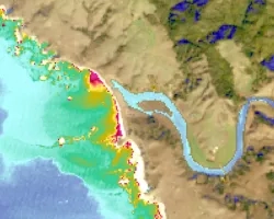
Nearly a quarter of California's fresh water supply flows through the Sacramento-San Joaquin Delta, an area comprised of tidal marshland and reclaimed land in the...
![NDWI-processed composite image from Landsat 8 OLI data of the Lower Illinois River Valley and surrounding landscapes from summer 2021. Shades of pale yellow indicate dry vegetation and dark teal represents open water, while brighter turquois values depict wet vegetation. Areas of high NDWI values are demonstrative of high presence of wet vegetation and are of interest to the Great Rivers Land Trust in identifying areas of interest for wetland conservation.](/sites/default/files/styles/lis/public/2022-12/2022Sum_JPL_LowerIllinoisEco_WebsiteImage.png.webp?itok=eCvz2h8C)
Lower Illinois River Valley Ecological Forecasting (Summer 2022) Team: Vanessa Machuca (Project Lead), Dana Myers, Hannah Rigdon, Christiana Saldana Summary: The Lower Illinois River Valley...