Displaying 1961 - 1970 of 3650
![Landsat 8 OLI derived MNDWI imagery mosaicked from October 17, 2020, to December 2, 2020. Located near the Río Patuca (Patuca River) in Ahuas, Honduras, permanent water and flood is represented as bright red and orange while blue depicts other land cover types and clouds. Examining floods from disasters like Hurricanes Eta and Iota helps decision makers improve mitigation and response efforts.](/sites/default/files/styles/lis/public/2022-03/2021Fall_MSFC_CentralAmericaDisasters_WebsiteImage.png.webp?itok=pweSILBO)
Central America Disasters (Fall 2021) Team: Caroline Williams (Project Lead), Lauren Carey, Maria De Los Santos, Deanna Fanelli, and Payton Ireland Summary: In November 2020...
![NDTI-processed imagery using 1999-2021 Landsat 7 ETM+ and Landsat 8 OLI data, processed with SHARQ and ORCAA. Displayed is an East-oriented view of St. Joseph Peninsula off the Florida panhandle. Brighter shades of pink indicate greater change in turbidity levels post-Hurricane Michael, while shades of purple represent lower turbidity change. This increase in sediment post-hurricane indicates disturbed aquatic vegetation due to extreme storm events.](/sites/default/files/styles/lis/public/2022-03/2021Fall_MSFC_StJosephPeninsulaDisasters_WebsiteImage.png.webp?itok=zl4XgGUp)
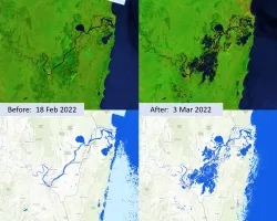
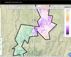
St. Joseph Peninsula Disasters (Fall 2021) Team: Erica Kriner (Project Lead), Paige Aldenberg, James Byrne, Brianne Kendall, and Nicholas Roberge Summary: T.H. Stone Memorial St...
![Terra MODIS-processed imagery using version 6 MOD16A2, calculated by averaging monthly evapotranspiration data from 2001 to 2020. This image includes several central Midwestern states along the Great Lakes. The lighter green areas indicate high levels of evapotranspiration affecting the water budget and health of agriculture while the purple areas represent no data values consistent of urban landscapes with impervious surfaces or large bodies of water.](/sites/default/files/styles/lis/public/2022-03/2021Fall_NC_MidwestWaterResources_RawWebsiteImage_RD.jpg.webp?itok=Q6pTpnRi)
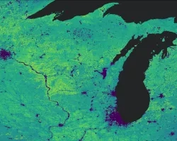
Midwest Water Resource (Fall 2021) Team: Emma Myrick (Project Lead), Erica Barth-Naftilan, Erin Shives, and Alec Solberg Summary: Evapotranspiration (ET) is a climatic variable critical...
Drobish-Application of Realtime Tactical Intelligence
Topic
Resource Type
![Ag 2022 Website Header](/sites/default/files/styles/lis/public/2022-03/Ag2022%20-%20Website%20_Header.png.webp?itok=qOt3YRE6)
Training Type
Level
Advanced
Date
April 12, 2022 - May 03, 2022
Earth Observations' Impacts ON Society
Earth observations play an integral role in society.
![](/sites/default/files/styles/lis/public/Australia%20Flood%20Extent%20Feb-March%202022.jpg.webp?itok=LEA83blx)